Interpretation of an early eighteenth century rural landscape
Date : 1998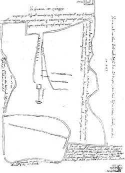
In conjunction with proceedings at the level of the Civil Court regarding the ownership of a significant tract of land, an interpretation of a site on a clayey slope was undertaken on behalf of the defendant. An early eighteenth century contract was the proof of ownership being contested. This contract included a sketch plan, with annotations, showing the extent of the territory being transacted.
Following historical research on the contract and on the site in dispute, supplemented with extensive field studies ranging from surveying to mapping clay movements over the centuries, the extent of the property indicated on the historic drawing was located. The sketch plan, signed by two architects, did not include a scale bar. A number of key features on site and stated linear measurements, one of which was tied with a permanent feature on site, were instrumental. By identifying these features and giving them linear dimensions, together with the stated site area, the location of the site in question was plotted on recent ordinance survey sheets. The resulting plot was 1% more than the area stated in the contract whilst the area of the interpretative plan put forth by the plaintiff was 35% more than that stated in the deed.
Click here to view the early 18th centuary contract.